


🌍 Chart Your Course with Confidence!
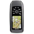
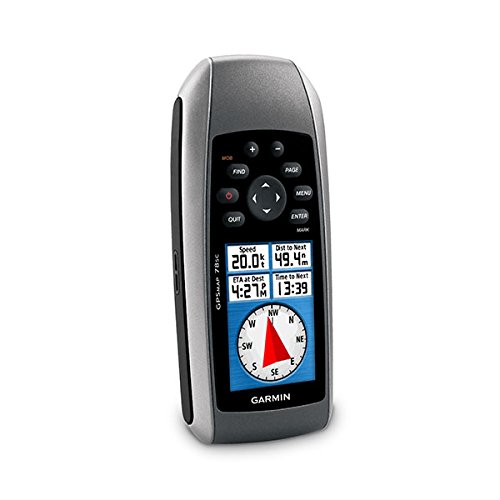
The Garmin GPSMAP 78S is a versatile marine GPS navigator featuring a 2.6-inch TFT LCD display, a 3-axis electronic compass, and a barometric altimeter. With a buoyant design and a microSD card slot for optional mapping, this device is perfect for boating enthusiasts who demand reliability and precision on the water.

| Item Weight | 7.7 Ounces |
| Item Dimensions L x W x H | 1.2"L x 2.6"W x 6"H |
| Battery Average Life | 20 Hours |
| Connectivity Technology | gpsmap |
| Control Method | Touch |
| Human-Interface Input | Buttons |
| Resolution | 160 x 240 |
| Compatible with Vehicle Type | Boat |
| Map Types | Worldwide |
| Connectivity Protocol | GPSmap |
| Display Type | LCD |
| Compatible Devices | Smartphone |
| Supported Satellite Navigation System | GPS |
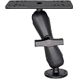
| Mount Type | Dashboard Mount, found in image |
| Screen Size | 2.6 Inches |
| Memory Storage Capacity | 1724 MB |
| Are Batteries Included | Yes |
| Sport Type | Fishing |
| Additional Features | Rugged case, Garmin HotFix, Photo navigation, Barometric altimeter, Garmin Connect compatible, Electromagnetic compass, Custom POIs, Automatic routing, Hunt/fish calendar, Geocaching |
T**R
The future is now
I've had some experience with the older GPS 76 and found it very hard to see in bright sunlight out on the water.So, I was a bit nervous in ordering the GPS 78sc without being able to kick the tires. It arrived yesterday and I've spent about 6 hours total getting used to it. There were several concerns that I, at first, felt like I had bought a pig in a poke -- BUT, after a couple of phone calls talking to the Garmin technical people, all my issues were resolved.This device is simply incredible with its accuracy and features for such a small package. I rely heavily on the MOB (man overboard) screen for use in setting upwind marks at specific bearings and distances from the committee boat in Race Committee work for Offshore classes. The color screen is very easily seen in the brightest conditions. The track log and reciprocal bearing back to the committee boat are highlighted in different colors and make for a superb display.One of the reasons the color screen is so good (and they don't mention it anywhere) is that the lense window is polarized. I stumbled onto that by accident today on a hike while wearing my polarized sunglasses. I noticed that when turning the device at a right angle the image suddenly disappeared. That only happens when you are viewing a polarized lense from another polarized lense.Now that I am familiar with the 78sc, my ONLY complaint is that the on-line Operation Manual is woefully inadequate for anything other than a basic introduction. However, all of your technical questions (and I am sure you will have some0 will be answered by their Customer Service department. Unlike many other companies, you won't have to wait more than a minute or so before getting through to a tech specialist. Pretty impressive.Let me give you an example of how the Operation Manual suffers. Nothing in the on-line literature advertising the 78sc explains the setup capabilities of the compass feature. It is factory set to show a compass rose instead of degrees. I have a real need for this to be in degrees, and yet after playing with the device for over an hour, I could not locate any menu item that would allow me to change the display. I was quite disappointed in my purchase at this stage -- however, my first call to their tech people got me oriented in how to use the menu drop-down sub categories to find where I could make the setup change.My next issue was that I consistently found the compass bearing was always 10 degrees off from measurements made with my hand-bearing compass. I must have performed the compass calibration in the 78sc a dozen times -- all to know avail. Unbeknownst to me, the factory default for the compass feature is for TRUE north instead of Magnetic north. In my region of the country, eastern Virginia, the angular difference between true north and magnetic north (known as the declination) is ---- Ding ding --- 10 degrees. I stumbled on this by again calling the tech support and was led to the menu item where I could switch from True North to Magnetic North. The devices is now dead on with my hand-bearing compass.I also will be using this for my hiking adventures and purchased the Topo 24 -- Mid-Atlantic sw to provide topographic detail. This along with the built-in altimeter make this a powerful tool to have in your backpack.Having owned this for only two days, I obviously cannot speak to the reliability of the device over long term exposure to saltwater, etc. I had read a few negative reviews from purchasers on this issue on several other websites. But, I intend to keep such exposure to a minimum (i.e., not leave the device on-board), so I do not think this will be a problem for me.UPDATEI spent most of the day yesterday out in the bay doing mark boat duties for our Race Committee. The 78sc performed flawlessly and the accuracy of the MOB feature (pinging on the committee boat) was amazing. As the committee boat stayed put the whole day, I only had to ping it once and from then on I had accurate bearings and distances for setting and moving the upwind marks and the pin end of the starting line.I set the device on the top of the dash in the center console and it never budged, even in choppy waters, thanks to the rubber backing on the GPS.The coastal chart info is also detailed and accurate.I honestly cannot think of anything I would do to improve this device. If you have a need for it -- don't hesitate, buy it.
F**O
GPS marino
Muy bueno es este GPS garmin
R**R
I love it 'cept for leaky port covers.
This is a wonderful little device and I have used it extensively, including over a 47 day kayak trip from Anacortes WA to Petersburg AK. When functioning properly it is an awesome tool. However there are some design defects which I would like to see resolved.1. The rubber covers for USB and power ports are poorly designed and WILL leak salt water leading to corrosion. My other IPX 7 devices (camera, VHF radio, etc.) have more positive enclosures that never leak.2. When loaded with lots of waypoints and routes the device consumes more power. I was able to see this over many days use and found through experimentation as I deleted waypoints and routes as I journeyed forward. Prolly got a software loop that's evaluating everything always rather than what's presently relevant which as data grows never gets to sleep.3. Unit OFTEN locked up while navigating a route. This would require popping the protective cover off, removing batteries and restarting. Not something you want to do while in windy wavy conditions! Eventually I stopped using this feature but that's just a shame.Let me reiterate that when it works I love it. I have taken to coating protective covers with Aquaseal before paddling on salt water. However I then have to remove it before I can connect USB to computer which is obviously a hassle. As I said I WANT to love it and seems they are VERY close to a great design. Wouldn't be nice if they listened to their customers a little better?January 7, 2020: I would like to add to my review. Last summer circumnavigated Vancouver Island by kayak over 34 days. I again loaded my GPSMAP with lots of data including waypoints and tracks. Battery performance was very much improved and while following tracks it never locked up. My impression is that software changes have fixed my complaints. Sadly port covers are still poorly designed and will leak.
Trustpilot
1 day ago
3 weeks ago